

ossettweather.com
It’s the time of year when harvesting on the plot is replaced by stored produce from the summer harvests either from the freezer or potatoes stored in boxes in the garage. Early October was still capable of producing a plentiful supply of fresh goodies from the plot but by the month’s end the summer bounty has come to an end although we still have a plentiful supply of winter vegetables such as carrots, parsnips and cabbage.

Rainfall was lower than average in October with a little more than half the expected rainfall in the month. Rainfall was recorded on 17 days in the month but it only exceeded 2mm on 3 of those days.
Temperature Data
Maximum temperature [warmest day?] 18.4°C on 10th October at 15:30
Lowest maximum temperature [coldest day] 8.2°C on 20th October
Minimum temperature [coldest night] 0.2°C on 25th October at 08:30
Maximum average temperature 14.2°C on 8th October
Lowest average temperature 4.2°C on 25th October
Maximum temperature variation in 24hrs 12.5°C on 17th October [14.2°C to 1.7°C]
Smallest temperature variation in 24hrs 2.2°C on 9th October [14.3°C to 12.1°C]
Rainfall Data
Rainfall in month 42.8 mm (long term average 68.7mm)
Wettest day in month 3rd October 17.4mm
Highest rain rate 86.6mm/hr at 14:00 on 3rd October
Wind Speed Data
Maximum wind speed 5.0 mph
Maximum wind gust speed 18.0 mph on 29th October (13:29)
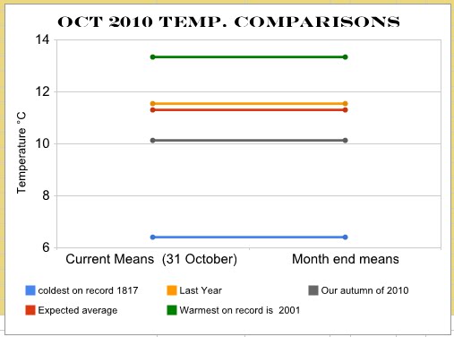
October 2010 Weather Data
1.jpg)
In the end October turned out to be below average temperature wise.
October 2010 Weather Summary
October started and ended on with reasonably mild days but in between the weather was cooler and towards the end of the month we had our first autumn frost, enough to blacken the dahlias and put a stop to any more cut flowers.
MONTHLY CLIMATOLOGICAL SUMMARY for OCT. 2010
NAME: Ossett Weather Station CITY: Ossett COUNTY: West Yorkshire
ELEV: 65 m LAT: 53° 40' 39" N LONG: 1° 33' 26" W
TEMPERATURE (°C), RAIN (mm), WIND SPEED (mph)
HEAT COOL AVG
MEAN DEG DEG WIND DOM
DAY TEMP HIGH TIME LOW TIME DAYS DAYS RAIN SPEED HIGH TIME DIR
-
1 12.3 14.4 17:00 9.0 00:00 6.0 0.0 10.0 1.6 15.0 10:30 SE
2 10.7 15.0 13:00 5.1 8:00 7.6 0.0 0.2 0.3 9.0 15:00 SSE
3 11.3 14.5 13:30 8.8 00:00 7.0 0.0 17.4 0.5 8.0 10:00 E
4 11.2 17.7 15:00 5.8 7:00 7.2 0.0 0.0 0.4 9.0 15:00 SE
5 13.8 18.1 16:00 10.2 23:00 4.5 0.0 0.0 0.5 11.0 15:00 WSW
6 12.3 16.2 13:00 9.0 22:30 6.0 0.0 1.8 0.8 14.0 13:00 WSW
7 11.1 16.8 15:00 5.1 7:30 7.3 0.0 0.0 0.6 9.0 14:00 SE
8 14.3 16.3 15:00 11.2 0:30 4.0 0.0 0.4 1.6 13.0 22:30 E
9 13.2 14.3 14:00 12.1 00:00 5.1 0.0 0.6 2.8 13.0 12:30 E
10 13.4 18.4 15:30 10.1 00:00 4.9 0.0 0.0 2.1 13.0 15:00 ENE
11 10.3 14.0 15:00 6.6 7:00 8.0 0.0 0.0 1.3 11.0 12:00 ENE
12 9.4 12.5 15:30 7.2 20:00 8.9 0.0 0.0 0.7 7.0 1:00 ENE
13 9.0 12.8 13:30 6.3 21:00 9.3 0.0 0.0 0.3 5.0 0:30 E
14 10.0 12.3 14:30 8.4 6:30 8.3 0.0 0.2 0.1 6.0 9:30 NW
15 10.4 13.4 15:30 7.5 00:00 7.9 0.0 0.4 0.5 12.0 16:30 WNW
16 8.9 12.6 12:30 6.7 00:00 9.4 0.0 0.2 0.8 11.0 13:30 ENE
17 8.0 14.2 13:30 1.7 8:00 10.3 0.0 0.0 0.5 7.0 12:30 WSW
18 11.2 13.7 13:30 8.1 00:00 7.1 0.0 1.4 2.2 16.0 14:00 W
19 7.7 12.3 12:30 3.8 00:00 10.6 0.0 1.2 1.3 12.0 17:00 WNW
20 4.6 8.2 13:30 1.5 6:00 13.8 0.0 0.0 1.6 11.0 11:00 WNW
21 8.6 11.7 14:00 4.8 0:30 9.7 0.0 0.2 2.8 16.0 15:00 W
22 10.7 14.1 13:30 8.8 7:00 7.6 0.0 0.2 2.1 14.0 10:00 WSW
23 8.3 10.8 2:30 3.9 00:00 10.0 0.0 1.6 1.5 13.0 2:30 WNW
24 5.2 10.1 12:30 1.9 23:30 13.1 0.0 0.0 0.9 10.0 13:30 WNW
25 4.2 10.1 13:30 0.2 8:30 14.1 0.0 0.0 0.6 10.0 15:00 WSW
26 9.5 14.7 22:30 2.3 0:30 8.8 0.0 4.4 0.9 15.0 23:00 WSW
27 13.3 16.2 14:00 10.9 20:00 5.0 0.0 0.2 2.7 17.0 3:30 W
28 11.7 14.7 13:30 8.9 9:00 6.6 0.0 0.2 1.6 13.0 0:30 W
29 12.9 14.3 15:00 10.1 23:30 5.4 0.0 0.0 2.8 18.0 13:30 W
30 9.8 13.7 14:00 5.2 00:00 8.5 0.0 0.0 0.6 10.0 12:00 W
31 8.5 10.4 14:30 4.7 1:00 9.8 0.0 0.0 0.3 5.0 12:30 ESE
-
10.2 18.4 10 0.2 25 251.9 0.0 40.6 1.2 18.0 29 W
Max >= 32.0: 0
Max <= 0.0: 0
Min <= 0.0: 0
Min <= -
Max Rain: 17.40 ON 03/10/10
Days of Rain: 17 (> .2 mm) 3 (> 2 mm) 0 (> 20 mm)
Heat Base: 18.3 Cool Base: 18.3 Method: Integration