
Thursday, 09 May 2019
Cold Daytime May Day
Wednesday produced the coldest daytime high I've recorded since 2010. The thermometer struggled up to 8.6°C (47.5°F) at 13:10 taking over the record from 19 May 2012 which stood at 8.7°C or 47.7°F.
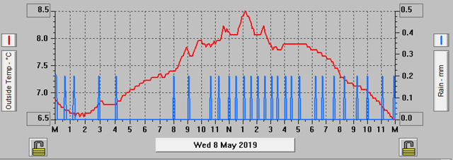
Temperature & Rainfall Records for 08-May-2019
To accompany the low temperature we had some rainfall throughout the day. It was never really very heavy and amounted to 5.6mm (0.22in) by the end of the day. We're up to 22.8mm (0.9in) of rainfall already this month, more than we had in the whole of April. The rain at any rate will be good for the garden and allotment although the cold weather isn't.
This May is the second coldest I've recorded at this early stage of the month. May 2012 was particularly cold early on but it did go on to warm up later in the month.
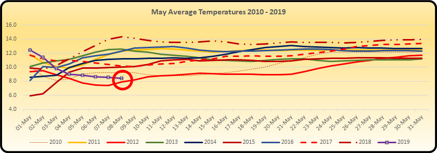
The graph above is a bit messy but it is intended to highlight extremes rather than the conglomeration of lines in the centre of the chart. As you can see the purple line representing this year's average temperature only has the red line of May 2012 below it. Hopefully, this year will warm up too.
We did have a visit to the plot on Tuesday to check if our frost protection had worked. Nothing seemed to have suffered and even the flowers on our strawberry plants hadn't been caught as they didn't have a black centre.
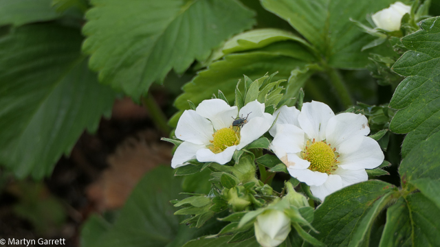
Strawberry - Sweetheart
However, at least one of the weather models is predicting temperatures down to freezing before this cold spell ends so we are not out of the woods just yet. We're keeping our fingers crossed though, especially for the strawberry flowers as unlike the potatoes they definitely won't recover from any frost damage.
Friday, 10 May 2019
Warmth Required!
It's gone on long enough now, we need some warmer days to get things growing even in the greenhouse. Another record breaking cold day for May saw a new record low daytime high for May as the temperature struggled to 8.1°C or 46.6°F. That's only just above what we can expect as an average night time value. Gardening is on hold until better weather arrives.
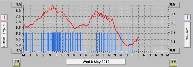
Temperature & Rainfall Records 08-10 May 2018
Not only has it been cold, but we've seen next to no sunshine so greenhouse temperatures have been cold throughout the day only managing to make it into the low teens Celsius or low fifties Fahrenheit.
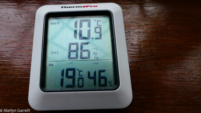
Greenhouse Temperature on 10 May 2019 at 10:00am
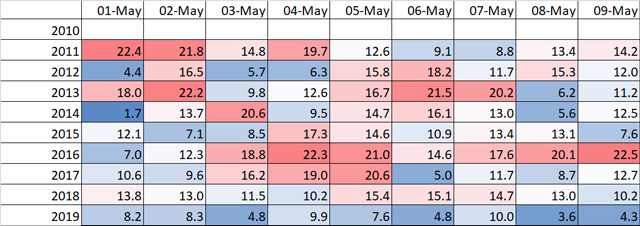
Sunshine Records May 2011 - May 2019
The table above is representative of the sunshine we've had and while it's not a measure of sunshine hours but of energy measured from the sunshine, it's a useful indicator of how much sunshine we've had. It's colour coded in my usual fashion from the highest values in red and the lowest in blue. Blue indicates cloudy days through to deep red representing the sunniest days. As you can see this May has started off with a row of blue, the first time that's happened over the last nine years.
If the forecast is correct, we should see a change in the weather next week with high pressure settling in over the country bringing with it more settled conditions and something a little bit warmer.